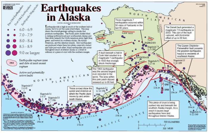
Plate tectonics fundamentally explains how the landscape of Denali National Park was built and why the mountain of Denali rises to 20,310 feet (US.NPS-1). Convection currents in the Earth’s molten mantle move the plates of the crust.

The denser oceanic Pacific plate constantly moves 2-3 inches per year towards the North American Plate of Alaska and goes beneath, through subduction (US.NPS-2).

This collision creates mountain uplift of the Alaska Range. Additionally, the plate convergence created the Denali transform fault, with the land to the South of the fault moving West at 1 cm per year. The fault is curved just North of the mountain of Denali. This contributes to further mountain building, as lateral movement along the fault makes land pile up (US.NPS-1).

The rock composition of the mountain also contributes to Denali’s height. While not a volcano, volcanic processes have developed Denali. Magma that cooled beneath the surface, forming a granite igneous batholith, makes up most of the mountain. Being less dense than adjacent rocks, over time this granite rose to the surface as Denali. The mountain continues to gain height at 0.5 millimeters per year and outpaces weathering and erosion, because of the resistant granite (US.NPS-1).

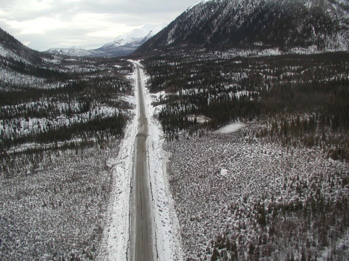
Running right by Denali, the Denali Fault triggers around 600 earthquakes a year within the park that are at least a magnitude 1. On November 3, 2002, the largest earthquake recorded in the interior of Alaska, at 7.9 magnitude, shook the park from its epicenter along the Denali Fault, 30 miles away (US.NPS-3). It caused offsets and cracks in the ground over 20 feet wide in some locations. Scientists study the fault because of its similarities to the San Andreas Fault, which could produce more destruction to dense human population (NASA).


Thus, the complex interaction of plate subduction, faults, and volcanic processes continues to produce the landscape of Denali, as well as shape the lives of the people living in the area.
References
Dr. Casey D. Allen, Associate Professor, Department of Geography & Environmental Sciences University of Colorado Denver: Geographic concepts and understanding were taken from lectures on building Earth’s landscapes in his Introduction to Physical Geography class.
United States. National Park Service. “The Alaska Range and Denali: Geology and Orogeny (U.S. National Park Service).” National Parks Service. U.S. Department of the Interior, n.d. Web. 25 Oct. 2016. https://www.nps.gov/articles/denali.htm, Article-1
United States. National Park Service. “Earthquake and Seismic Monitoring in Denali (U.S. National Park Service).” National Parks Service. U.S. Department of the Interior, n.d. Web. 25 Oct. 2016. https://www.nps.gov/articles/aps-v5-i1-c6.htm, Article-2
United States. National Park Service. “Earthquakes & Tectonics.” National Parks Service. U.S. Department of the Interior, n.d. Web. 25 Oct. 2016. https://www.nps.gov/dena/learn/nature/earthquakes.htm, Article-3
NASA. “Denali’s Fault.” NASA: Earth Observatory. NASA, 13 Nov. 2003. Web. 25 Oct. 2016. http://earthobservatory.nasa.gov/Features/denali/
Figure References
Figure 1: United States National Park Service Article-1 (US.NPS-1) and The United States Geological Survey
Figure 2: United States National Park Service Article-2 (US.NPS-2)
Figure 3: NASA
Figure 4: By USGS [Public domain], via Wikimedia Commons, https://upload.wikimedia.org/wikipedia/commons/8/8d/Alaska_earthquakes.jpg
Figure 5: NASA and USGS
Figure 6: By U.S. Geological Survey [Public domain], via Wikimedia Commons, https://upload.wikimedia.org/wikipedia/commons/e/e8/Tok_Cutoff_USGS.jpg
Header Image: By Nic McPhee from Morris, MN, USA (Road to special places) [CC BY-SA 2.0 (http://creativecommons.org/licenses/by-sa/2.0)%5D, via Wikimedia Commons, https://commons.wikimedia.org/wiki/File%3AMount_McKinley_Alaska.jpg